Skip to content

All posts by David Jourdan

Iowa State University Lockheed Electra Structural Analysis

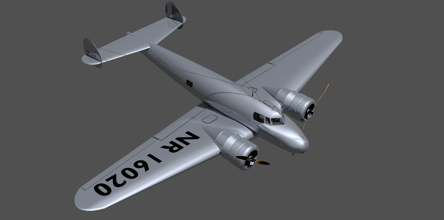
One of the enduring uncertainties regarding our Amelia Earhart search project is the issue of whether the L-10E Electra broke into pieces upon impact, and, whether or not, how long did it float? We know the prevailing winds and currents well enough to estimate the impact of float time on the search area, if we can get a better handle on the time. We have always assumed the plane would sink rather quickly, and would probably remain largely intact, but this is based entirely on anecdotal evidence. We have recently selected a proposal by Iowa State University to “conduct deeper research into the structural failure of Amelia Earhart’s Lockheed L-10E airplane, relative to the dump valves and associated fuel tanks. The structural failure analysis of the valves will be useful in providing the fill rate and float time when the aircraft crashed into the ocean. This information contributes to the ongoing search analysis for Amelia Earhart’s plane.” The project would include creating a CAD model, performance of simulations, and construction and testing of a prototype tank and dump valve system to test static and dynamic forces on the tanks.
The project will be led by ISU professor Dr Emmanuel Agba of the Mechanical Engineering Department. Students working on the project will build upon the work previously done by Dr. Gerardo Olivares; they are validating and expanding his work to complement their effort. The total cost for this project is about $45,000, mostly ISU work (student stipends, use of university facilities, fabrication and testing of prototypes), travel, and SeaWord outreach (video documentation, website, PR, stipends).  You can help offset this cost with a tax-deductible contribution; go to our website seaword.org and donate on-line, or of course you can send a check to PO Box 7689, Cape Porpoise, ME 04014.

Weather

The Okeanos Explorer is currently operating near an undersea feature called Pioneer Tablemount, southeast of Midway Atoll, 1,000 miles from Honolulu. This largely unexplored pinnacle rises from the seafloor over 5,000 meters deep to nearly the surface. Screen Shot 2016-03-04 at 4.44.53 PM (2)A spectacular ROV dive is currently taking place this afternoon of March 4th, revealing incredible sea life such as the transparent sea cucumber at left. These creatures are usually seen on the bottom, but this one was found free swimming, its undulating body moving it steadily by, at a depth of over 1,000 meters. Viscera can be seen inside its clear outer body.

Unfortunately, gusting winds and high seas have forced cancellation of several ROV dives over the last few days, and postponed our planned weekend operations on the Battle of Midway site. We are holding out hope that the weather will abate and dives can take place early next week, though the forecast is not promising.

Screen Shot 2016-03-01 at 10.42.44 AMThe image at right, from Natural Earth, gives an idea what we’re up against. With the view centered roughly over our operations area, this snapshot from March 1 shows a couple of major storm systems passing through the region. History shows a 20% chance of seas exceeding twelve feet during the winter months in this part of the world, and we are definitely falling within that unlucky circumstance.

Regardless of the weather, the mapping team has been extremely productive during the last couple of days and filled in some important gaps around Pioneer Bank. These efforts included the mapping of a completely new seamount to the west of Pioneer Bank Ridge.

Please check out our Expedition Portal to see live imagery, replays of earlier dives, and other information about this important and exciting NOAA expedition.

Expedition Portal Launched

Screen Shot 2016-02-29 at 9.34.06 AMThe NOAA Okeanos Explorer is currently at sea mapping and imaging sites from Necker Ridge to French Frigate Shoals in the Northwest Hawaiian Islands chain. Spectacular images from the seafloor have been collected, as well as rock and biological samples. As of February 29, the vessel is dealing with very bad weather and has cancelled the day’s dive. However, one can see replays of earlier dives and follow developing events live though our new Expedition Portal. This site has been launched to support educational outreach and general public interest in undersea exploration as we plan dives on the site of the Battle of Midway on March 5 and 6. Besides the live feeds, one can explore the history of the battle, view images of prior expeditions, learn about the science and technology of deep sea research. Educational materials and mission updates will be added over the course of the expedition.

Click on the image to launch the Portal. Check out Camera 1 and 2 to see what is happening and replays of earlier ROV dives. Select “Where is the Okeanos” to see where the vessel is and has been. Dive into the Portal windows to learn more. Keep checking as we upload new content during the expedition. And share the link with anyone interested in exploration!

Collins Aerospace

This Portal was made possible by the generous support of Collins Aerospace and the SeaWord Foundation.

ROV Technology

Oceaneering's SpiderBOT™
Oceaneering’s SpiderBOT™

ROVs – Remotely Operated Vehicles – allow us to look and touch at the bottom of the ocean where no human can survive. Most deep sea ROVs can dive to 6,000 m (20,000 feet), allowing them to reach 95% of the ocean floor. At that depth, water pressure approaches 9,000 psi! Tethered to a research vessel with a long cable that provides power and receives images and telemetry, the ROV uses thrusters to move and position itself to get the best view or grab the most valuable sample with its robot arms. ROVs come in many sizes, from the monster machines that service offshore oil installations or bury cables, to the suitcase-sized SpiderBOTs made famous in the movie Titanic.

In 1999, Nauticos used an ROV operated by the Naval Oceanographic Office to discover wreckage from the Japanese aircraft carrier Kaga, sunk at the Battle of Midway in 1942. You can read about this project and the history of the battle in The Search for the Japanese Fleet. Nauticos and the SeaWord Foundation plan to work with NOAA’s Deep Discoverer ROV in early March to return to the site and capture hi-def video of the wreckage, far superior to what was possible nearly 20 years ago.

This 4-ton artifact was recovered from 10,000 feet using ROV technology.
This 4-ton artifact was recovered from 10,000 feet depth using ROV technology.

Nauticos also used the ROV Remora in 1999 to identify the wreck of the Israeli submarine Dakar, and returned to the site the following year to recover a 4-ton artifact from the seafloor at 10,000 feet. Operators on the ship high above watched through remote cameras to operate mechanical arms and manipulators to attach a lifting line to the structure of the artifact so that a winch could slowly lift it to the surface. After nine hours, the conning tower of Dakar emerged from the sea after resting there for 31 years. The tower is now on display at the Naval Museum in Haifa, a memorial to the 69 sailors who lost their lives on the ill-fated warship. This story is chronicled in Never Forgotten: The Search and Recovery of Israel’s Lost Submarine Dakar. This 3-minute video, produced for the Maryland Science Center Titanic exhibition, includes scenes from that spectacularly successful Dakar recovery mission.

NOAA’s Undersea Robot Deep Discoverer

D2 discovers the remnants of asphalt volcanoes, or “tar lilies.” Image courtesy of NOAA Office of Ocean Exploration and Research, Okeanos Explorer Gulf of Mexico 2014 Expedition.
D2, as viewed by Seirios, discovers the remnants of asphalt volcanoes, or “tar lilies.” Image courtesy of NOAA Office of Ocean Exploration and Research, Okeanos Explorer Gulf of Mexico 2014 Expedition.

At a depth of nearly four miles, with four tons of crushing pressure on every square inch, in the pitch black of the deep ocean, the Remotely Operating Vehicle (ROV) Deep Discoverer lurks. Known as D2, the robot is operated by a team on the NOAA mother ship Okeanos, and via miles of cable sends back exquisite high-definition imagery from the unexplored seafloor. D2 is tethered to its sister vehicle, Seirios, which lights D2 from above and with its own cameras allows operators an expanded view of the ROV and its surroundings. Seirios in turn is dangled from Okeanos at the end of miles of steel-armored cable with a fiber-optic core. The cable provides power to the duo and is a conduit for communications and telemetry.

D2 illuminates its surroundings with brilliant LED lights, allowing its nine video cameras to capture an unparalleled view of the seafloor and close-up glimpses of the remarkable creatures that lurk there. And via telepresence, anyone, anywhere with an Internet connection can follow the excitement of discovery with scientists, watching it unfold as it happens. D2 can also grab samples of marine life and geology for further study topside.

The Nauticos-SeaWord team will be looking with great anticipation to seeing what D2 reveals when it dives on the Battle of Midway site near the end of its current mission to explore the Northwest Hawaiian Islands Marine National Monument in early March.


NOAA Okeanos Explorer Program

The NOAA Midway dives have been planned for March 5-7, subject to weather and other unforeseen circumstances that are a part of life at sea. Stay tuned for further details about how to follow this expedition. The vessel is currently in Hawaiian waters testing equipment in preparation for its main mission which will begin around February 23rd: Map

The Okeanos Explorer program is one of exploration and discovery, designed to achieve a first-look at the unknown seafloor that will inspire further research. It is a highly collaborative process that involves the entire science community, so that new discoveries are available to everyone. All data is shared in real-time during the cruise through telepresence. Educational outreach is a major component, and public access is encouraged, including through the SeaWord Foundation. The current mission is to explore the Papahānaumokuākea Marine National Monument, encompassing the waters around the Northwestern Hawaiian Islands. It is the single largest fully protected conservation area under the U.S. flag, and one of the largest marine conservation areas in the world. A UNESCO World Heritage Site, the preserve includes deep and shallow coral reefs, sea mounts harboring thousands of marine species, hundreds of islets home to 14 million seabirds, and cultural resources of importance to native Hawaiians as well as historians of World War II.

Papahanaumokuakea

Join us at the Bottom of the Sea

The Search for the Japanese Fleet Continues

Seventeen years ago, a small group of explorers set out to locate the wreckage of the Japanese Fleet sunk at the Battle of Midway. Their purpose was to use advanced technology to solve mysteries of the deep sea, to commemorate fallen heroes, to show to students the rewards of the pursuit of scientific and technical education, and to share with the public the thrill of discovery. On two expeditions, forty-one scientists and engineers sailed with forty-four ship’s crew (plus one owl), and together scoured the ocean floor over three miles down. In time, they were rewarded with sonar and visual evidence of one of the great ships they sought: the 800-foot long, 40,000 ton aircraft carrier Kaga. Fewer than two dozen people have had the opportunity to see imagery of this wreckage in real time, in person, and I can assure you it is an experience one can never forget.

But there is so much more to locate and learn; the wreckage we found, though definitive, is a small fraction of the vast historical treasure awaiting us. Join us as we return to the site of our 1999 discovery and be among the first to see this unknown landscape and further explore the echoes of history as we continue our Search for the Japanese Fleet.

Check this space in the coming weeks to learn how to connect via telepresence and experience the expedition first hand. Meanwhile, be sure to visit and like our Facebook pages Nauticos and SeaWord Foundation.

3_REV2